mwp Configuration#
Overview#
mwp stores configuration in a number of places, to some degree at the developer's whim, but also in accordance with the data item's volatility.
- Command line options
- Configuration Files
- dconf / gsettings
Each type is further discussed below.
Command line options#
Command line options provide a 'per instantiation' means to control mwp behaviour; the current set of command line options may be viewed by running mwp from the command line with the single option --help:
$ mwp --help
Where it is required to give permanence to command line options, they can be added to the configuration file $HOME/.config/mwp/cmdopts, which is described in more detail in the following section.
You can also use a system-wide "cmdopts" file, /etc/default/mwp. If this flie exists, it will read before the user's file.
- For singular options, any option in the user file will override the system file
- For multiply occurring options, e.g.
--radar-device, definitions will be additive. - Environment variables can be set from either or both files.
Debug flags#
The --debug-flags option takes a numeric value defines areas where additional debug information may be output.
| Value | Usage |
|---|---|
| 1 | Waypoints |
| 2 | Startup |
| 4 | MSP |
| 8 | ADHOC |
| 16 | RADAR |
| 32 | (unused) |
| 64 | SERIAL |
| 128 | VIDEO |
| 256 | GCS Location |
Values may be added together (so 511 means all).
Configuration Files#
mwp configuration files are stored in a standard directory $HOME/.config/mwp. This directory is created on first invocation if it does not exist. The following files may be found there:
cmdopts#
The file cmdopts contains command line options that the user wishes to apply permanently (and conveniently when run from a launcher icon rather than the command line).
The file contains CLI options exactly as would be issued from the terminal. Options may be on separate lines, and blank lines and line prefixed with a hash '#' are ignored. For example:
In addition to options (--), the file may also contain environment variables e.g. FOO=BAR.
# Default options for mwp
--rings 50,20
#--voice-command "spd-say -t female2 -e"
#--debug-flags=2
--dont-maximise
#-S 8192
# set the anonymous tile file.
MWP_BLACK_TILE=/home/jrh/.config/mwp/mars.png
So here the only current, valid options are --rings 50,20 --dont-maximise, and the environment variable MWP_BLACK_TILE is set (for anonymous maps).
The environment is set before any GTK / UI calls are made.
mwp (and other applications) can have a problem with OpenGL and the Wayland compositor on GNOME (at least). Typcially this is manifest by being unable to pick mission WP icons for large (>40 point) missions. This problem does not occur with other compositors (wlroots based or WSL).
Using XWayland over Wayland may mitigate this. You can force Wayland / XWayland by setting the GDK_BACKEND variable in cmdopts (or the environment). This will override mwp's behaviour based on the Window Manager defaults.
# set XWayland
GDK_BACKEND=x11
# set Wayland
GDK_BACKEND=wayland
.layout#
.layout contains the current arrangement of Dock items. You are advised not to manually edit this file (or other named, alternate layout files).
sources.json#
sources.json facilitates adding non-standard map sources to mwp. See the anonymous maps section and comments in the source files in the qproxy directory.
Here is an example mwptools/src/samples/sources.json;(you need your own free API key for the Thunderforest examples):
Note that the mapping library used by mwp (libchamplain) replaces the standard TMS notation for coordinates {z}/{x}/{y} with # in place of the brackets #Z#/#X#/#Y#, and the variables are capitalised.
{
 "sources" : [
  {
   "id": "OCM",
   "name": "CycleMaps API key",
   "license": "(c) Thunderforest",
   "license_uri": "http://thunderforest.com/",
   "min_zoom": 0,
   "max_zoom": 19,
   "tile_size": 256,
   "projection": "MERCATOR",
   "comment": "You need your own (free) hobbist key from https://www.thunderforest.com/",
   "uri_format": "https://a.tile.thunderforest.com/cycle/#Z#/#X#/#Y#.png?apikey=00000000000000000000000000000000"
  },
  {
   "id": "Landscape",
   "name": "Landscape API key",
   "license": "(c) Thunderforest",
   "license_uri": "http://thunderforest.com/",
   "min_zoom": 0,
   "max_zoom": 19,
   "tile_size": 256,
   "projection": "MERCATOR",
   "comment": "You need your own (free) hobbist key from https://www.thunderforest.com/",
   "uri_format": "https://a.tile.thunderforest.com/landscape/#Z#/#X#/#Y#.png?apikey=00000000000000000000000000000000"
  },
  {
   "id": "OpenTopo",
   "name": "OpenTopo TMS",
   "license": "(c) OSM",
   "license_uri": "http://www.openstreetmap.org/copyright",
   "min_zoom": 0,
   "max_zoom": 19,
   "tile_size": 256,
   "projection": "MERCATOR",
   "uri_format": "https://a.tile.opentopomap.org/#Z#/#X#/#Y#.png"
  },
  {
   "id": "Black",
   "name": "Black Tiles",
   "license": "(c) jh ",
   "license_uri": "http://daria.co.uk/",
   "min_zoom": 0,
   "max_zoom": 20,
   "tile_size": 256,
   "projection": "MERCATOR",
   "spawn" : "bproxy"
  }
 ]
}
See also anonymous maps to customise the "black tile". The spawn stanza uses a proxy for non-TMS formats (see mwptools/src/qproxy for some examples).
vcol.css#
vol.css contains alternate CSS themeing for the battery voltage dock item that may work better on dark desktop themes. An example file is provided as mwp/vcol.css which can be copied into .config/mwp/.
places#
The places (~/.config/mwp/places) file is a delimited (CSV) file that defines a list of "shortcut" home locations used by the "View / Centre on Position ..." menu item. It consists of a Name, Latitude, Longitude and optionally zoom level, separated by a TAB,|,: or ;. Note that positions may be localised in the file and thus . is no longer recognised as a field separator.
Example places
# mwp places name,lat,lon [,zoom]
Beaulieu|50.8047104|-1.4942621|17
Jurby:54.353974:-4.523600:-1
The user may maintain these files manually if used, or use the graphic places editor. The command line option --centre accepts a place name as well as a geographic coordinates.
Dconf / gsettings#
The underlying infrastructure used by mwp has a facility for storing configuration items in a registry like store. This is used extensively by mwp. The items can viewed and modified using a number of tools:
- mwp preference dialogue (for a small subset of the items)
- The
dconf-editorgraphical settings editor - The command line
gsettingstool
For gsettings and dconf-editor, the name-space is org.mwptools.planner, so to view the list of items:
$ gsettings list-recursively org.mwptools.planner
and to list then get / set a single item:
$ gsettings get org.mwptools.planner log-save-path
..
$ gsettings set org.mwptools.planner log-save-path ~/flight-logs/
dconf-editor#
This may not be installed by default, but should be available via the OS package manager / software centre.
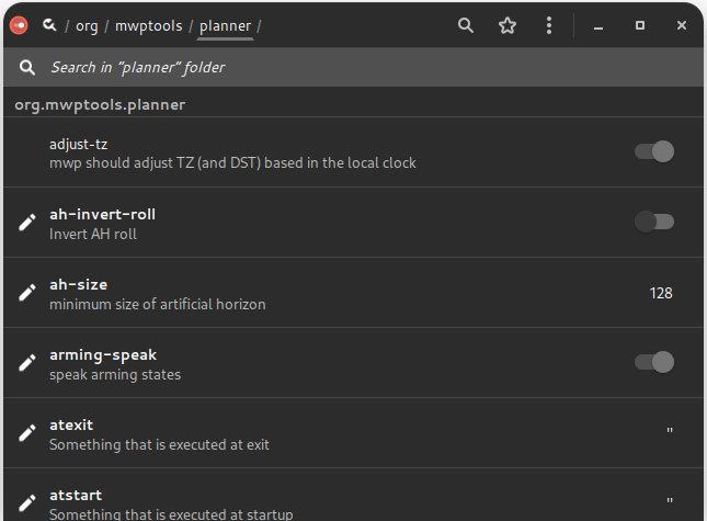
List of mwp settings#
| Name | Summary | Description | Default |
|---|---|---|---|
| adjust-tz | Adjust FC's TZ (and DST) | mwp should adjust FC's TZ (and DST) based on the local clock | true |
| ah-invert-roll | Invert AH roll | Set to true to invert roll in the AH (so it becomes an attitude indicator) | false |
| ah-size | minimum size of artificial horizon | (private setting) | 32 |
| arming-speak | speak arming states | whether to reporting arming state by audio | false |
| atexit | Something that is executed at exit | e.g. gsettings set org.gnome.settings-daemon.plugins.power idle-dim true. See also manage-power (and consider setting manage-power to true instead). |
"" |
| atstart | Something that is executed at startup | e.g. gsettings set org.gnome.settings-daemon.plugins.power idle-dim false. See also manage-power (and consider setting to true). |
"" |
| audio-bearing-is-reciprocal | Announce bearing as reciprocal | Whether the audio bearing is the reciprocal (i.e. bearing from home to machine, rather than from machine to home) | false |
| audio-on-arm | start audio on arm | start audio on arm (and stop on disarm) | true |
| auto-follow | set auto-follow | set auto-follow on start | true |
| auto-restore-mission | Whether to automatically import a mission in FC memory to MWP | If the FC holds a valid mission in memory, and there is no mission loaded into MWP, this setting controls whether MWP automatically downloads the mission. | false |
| auto-wp-edit | Whether direct WP editing is available | If true, the user can edit / create waypoints directly by clicking on the map, if false, it is necessary to toggle the WP Edit button to enable editing. | false |
| autoload-geozones | Autoload geozones from FC | Autoload geozones from FC on connect, remove from display on disconnect | true |
| baudrate | Baud rate | Serial baud rate | 115200 |
| blackbox-decode | Name of the blackbox_decode application | Name of the blackbox_decode application (in case there are separate for iNav and betaflight) | "blackbox_decode" |
| bluez-disco | Use Bluetooth discovery | Only discovered Bluetooth serial devices with non-zero RSSI will be offered | false |
| centre-on | centre map on GPS | centre map on GPS as needed | true |
| checkswitches | check switches | check switches (an ancient JH sanity check) | false |
| compat-version | mw-nav compat version | Default mw-nav compat version in XML files. mwp doesn't care, older (MW) applications might. | "42.0" |
| dbox-is-horizontal | Geometry of the DirectionView box | If true, uses a horizontal organisation, rather than vertical | false |
| default-altitude | Default altitude | Default Altitude for mission (m) | 20 |
| default-latitude | Default Latitude | Default Latitude when no GPS | 50.909528 |
| default-layout | Default layout name | Default layout name. If not set, .layout is used. | "" |
| default-loiter | Default Loiter time | Default Loiter time | 30 |
| default-longitude | Default Longitude | Default Longitude when no GPS | -1.532936 |
| default-map | Default Map | Default map key | "" |
| default-nav-speed | Default Nav speed | Default Nav speed (m/s). For calculating durations only. | 2.5 |
| default-zoom | Default Map zoom | Default map zoom | 15 |
| delta-minspeed | Minimum speed for elapsed distance updates | Minimum speed for elapsed distance updates (m/s). Default is zero, which means the elapsed distance is always updated; larger values will take out hover / jitter movements. | 0.0 |
| device-names | Device names | A list of device names to be added to those that can be auto-discovered | [] |
| display-distance | Distance units | 0=metres, 1=feet, 2=yards | 0 |
| display-dms | Position display | Show positions as dd:mm:ss rather than decimal degrees | false |
| display-speed | Speed units | 0=metres/sec, 1=kilometres/hour, 2=miles/hour, 3=knots | 0 |
| dump-unknown | dump unknown | dump unknown message payload (debug aid) | false |
| espeak-voice | Default espeak voice | Default espeak voice (see espeak documentation) | "en" |
| fctype | Force fc type | Forces fc type (mw,mwnav,bf,cf) | "auto" |
| flash-warn | Flash storage warning | If a dataflash is configured for black box, and this key is non-zero, a warning in generated if the data flash is greater than "flash-warn" percent full. | 0 |
| flite-voice-file | Default flite voice file | Default flite voice file (full path, *.flitevox), see flite documentation) | "" |
| forward | Types of message to forward | Types of message to forward (none, LTM, minLTM, minMAV, all) | "minLTM" |
| ga-alt | Units for GA Altiude | 0=m, 1=ft, 2=FL | 0 |
| ga-range | Units for GA Range | 0=m, 1=km, 2=miles, 3=nautical miles | 0 |
| ga-speed | Units for GA Speed | 0=m/s, 1=kph, 2=mph, 3=knots | 0 |
| geouser | User account on geonames.org | A user account to query geonames.org for blackbox log timezone info. A default account of 'mwptools' is provided; however users are requested to create their own account. | "mwptools" |
| gpsd-host | gpsd provider | Provider for GCS location via gpsd. Default is "localhost", can be set to other host name or IP address. Setting blank ("") disables. | "localhost" |
| gpsintvl | gps sanity time (m/s) | gps sanity time (m/s), check for current fix | 2000 |
| heartbeat | Something that runs every minute | e.g. xscreensaver-command -deactivate. See also manage-power (and consider setting to manage-power to true). |
"" |
| ignore-nm | Ignore Network Manager | Set to true to always ignore NM status (may slow down startup) | false |
| kml-path | Directory for KML overlays | Directory for KML overlays, default = current directory | "" |
| led | GPS LED colour | GPS LED colour as well know string or #RRGGBB | "#60ff00" |
| load-safehome | Load default set of safehomes | Set to file[,Y]. File defines a set of safehome lines (CLI format), optionally followed by a comma and Y. If the definition includes ",Y", then the safehome locations will be displayed. If the name has the special value '-FC-', then safehomes will be loaded from the FC on connection. | "" |
| log-on-arm | start logging on arm | start logging on arm (and stop on disarm) | false |
| log-path | Directory for replay log files | Directory for log files (for replay), default = current directory | "" |
| log-save-path | Directory for storing log files | Directory for log files (for save), default = current directory | "" |
| los-margin | Margin(m) for LOS Analysis | Margin(m) for LOS Analysis | 0 |
| mag-sanity | Enable mag sanity checking | mwp offers a primitive mag sanity checker that compares compass heading with GPS course over the ground using LTM (only). There are various hard-coded constraints (speed > 3m/s, certain flight modes) and two configurable parameters that should be set here in order to enable this check. The parameters are angular difference (⁰) and duration (s). The author finds a settings of 45,3 (i.e. 45⁰ over 3 seconds) works OK, detecting real instances (a momentarily breaking cable) and not reporting false positives. | "" |
| manage-power | manage power and screen | whether to manage idle and screen saver | false |
| map-sources | Additional Map sources | JSON file defining additional map sources | "" |
| mavph | RC settings for Mav PH | RC settings for Mav PH (chanid:minval:maxval) | "" |
| mavrth | RC settings for Mav RTH | RC settings for Mav RTH (chanid:minval:maxval) | "" |
| max-climb-angle | Maximum climb angle highlight for terrain analysis | If non-zero, any climb angles exceeding the specified value will be highlighted in Terrain Analysis Climb / Dive report. Note that the absolute value is taken as a positive (climb) angle | 0.0 |
| max-dive-angle | Maximum dive angle highlight for terrain analysis | If non-zero, any dive angles exceeding the specified value will be highlighted in Terrain Analysis Climb / Dive report. Note that the absolute value is taken as a negative (dive) angle | 0.0 |
| max-home-delta | home position delta (m) | Maximum variation of home position without verbal alert | 2.5 |
| max-radar-slots | Maximum number of aircraft | Maximum number of aircraft reported by iNav-radar | 4 |
| max-wps | Maximum number of WP supported | Maximum number of WP supported | 120 |
| media-player | Media player for alerts | Blank means internal gstreamer, "false" or "none" means no beeps. | "" |
| misc-icon-size | Miscellaneous icon size | Size for miscellaneous icons (radar, GCS location) in pixels. -1 means the image's natural size (no scaling). | 32 |
| mission-file-type | Preferred mission file type | m for XML (.mission), j for json (change at your peril) | "m" |
| mission-meta-tag | use meta vice mwp in mission file | If true, the legacy 'mwp' tag is named 'meta' | false |
| mission-path | Directory for mission files | Directory for mission files, default = current directory | "" |
| osd-mode | Data items overlaid on the map | 0 = none, 1 = current WP/Max WP, 2 = next WP distance and course. This is a mask, so 3 means both OSD items. | 3 |
| poll-timeout | Poll messages timeout (ms) | Timeout in milliseconds for telemetry poll messages. Note that timer loop has a resolution of 100ms. | 900 |
| pos-is-centre | Determines position label content | Whether the position label is the centre or pointer location | false |
| pwdw-p | internal parameter | (private setting) | 72 |
| radar-alert-altitude | Altitude below which ADS-B alerts may be generated | Target altitude (metres) below which ADS-B proximity alerts may be generated. Requires that 'radar-alert-range' is also set (non-zero). Setting to 0 disables. Note that ADS-B altitudes are AMSL (or geoid). | 0 |
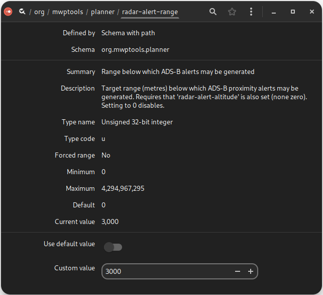
| radar-alert-range | Range below which ADS-B alerts may be generated | Target range (metres) below which ADS-B proximity alerts may be generated. Requires that 'radar-alert-altitude' is also set (non-zero). Setting to 0 disables. | 0 |
| radar-list-max-altitude | Maximum altitude for targets to show in the radar list view | Maximum altitude (metres) to include targets in the radar list view. Targets higher than this value will show only in the map view. This is mainly for ADS-B receivers where there is no need for high altitude targets to be shown. Setting to 0 disables. Note that ADS-B altitudes are AMSL (or geoid). | 0 |
| require-telemetry | Whether to warn the operator if telemetry is disabled in iNav | if set, and telemetry is disabled, a non-timeout dialogue is displayed | false |
| rings-colour | range rings colour | range rings colour as well know string or #RRGGBBAA | "#ffffff20" |
| rth-autoland | Set land on RTH waypoints | Automatically assert land on RTH waypoints | false |
| say-bearing | Whether audio report includes bearing | Whether audio report includes bearing | true |
| set-head-is-b0rken | set head bearing as reciprocal | Whether the set head bearing is the reciprocal (i.e. ancient bug in mw nav) | false |
| show-sticks | Whether to show sticks in log replay | If "yes", stick position is shown during log replay, if "no" , never shown. If "decorated", then shown in a decorated window (for window managers that can't cope with un-decorated windows), e.g. WSL, Cygwin | "yes" |
| smartport-fuel-unit | User selected fuel type | Units label for smartport fuel (none, %, mAh, mWh) | "none" |
| speak-amps | When to speak amps/hr used | none, live-n, all-n n=1,2,4 : n = how often spoken (modulus basically) | "none" |
| speak-interval | Interval between voice prompts | Interval between voice prompts, 0 disables | 15 |
| speech-api | API for speech synthesis | espeak, speechd, flite. Only change this if you know you have the required development files at build time | "espeak" |
| speechd-voice | Default speechd voice | Default speechd voice (see speechd documentation) | "male1" |
| stats-timeout | timeout for flight statistics display (s) | Timeout before the flight statistics popup automatically closes. A value of 0 means no timeout. | 30 |
| tote-float-p | Do Mission tote float | (private setting) | true |
| uc-mission-tags | Upper case mission XML tags | If true, MISSION, VERSION and MISSIONITEM tags are upper case (for interoperability with legacy Android applications) | false |
| uilang | Language Handling | "en" do everything as English (UI numeric decimal points, voice), "ev" do voice as English (so say 'point' for decimals even when shown as 'comma') | "" |
| use-legacy-centre-on | If true, uses legacy centre-on | If true, uses legacy centre-on mode (aka moving map with vehicle in centre) rather than the new "In View" mode. | false |
| vlevels | Voltage levels | Semi-colon(;) separated list of cell voltages values for transition between voltage label colours | "" |
| wp-dist-size | Font size (points) for OSD WP distance display | Font size (points) for OSD WP distance display | 56.0 |
| wp-spotlight | Style for the 'next waypoint' highlight | Defines RGBA colour for 'next way point' highlight | "#ffffff60" |
| wp-text-style | Style of text used for next WP display | Defines the way the WP numbers are displayed. Font, size and RGBA description (or well known name, with alpha) | "Sans 144/#ff000080" |
| zone-detect | Application to return timezone from location | If supplied, the application will be used to return the timezone (in preference to geonames.org). The application should take latitude and longitude as parameters. See samples/tzget.sh | "" |
Replicating gsettings between machines or users#
The standard system dconf application can be used to back up and restore the above gsettings.
To backup the settings:
dconf dump /org/mwptools/planner/ >/tmp/mwp-dconf.txt
To restore the settings (overwrite). This could be for a different user or on a new machine.
dconf load /org/mwptools/planner/ </tmp/mwp-dconf.txt
Settings precedence and user updates#
mwp installs a number of icon files in $prefix/share/mwp/pixmaps. The user can override these by creating an eponymous file in the user configuration directory, ~/.config/mwp/pixmaps/. Such user configurations are never over-written on upgrade.
For example, to replace a mwp specific icon; i.e. replace the GCS Location icon ($prefix/share/mwp/pixmaps/gcs.svg) with a user defined file ~/.config/mwp/pixmaps/gcs.svg.
While the file name must be consistent, the format does not have to be; the replacement could be be a PNG, rather than SVG; we're not MSDOS and file "extensions" are an advisory illusion.
Example#
e.g. replace the inav-radar icon.
mkdir -p ~/config/mwp/pixmaps
# copy the preview image
cp ~/.local/share/mwp/pixmaps/preview.png  ~/config/mwp/pixmaps/
# (optionally) resize it to 32x32 pixels
mogrify -resize 80% ~/config/mwp/pixmaps/preview.png
# and rename it, mwp doesn't care about the 'extension', this is not MSDOS:)
mv  ~/config/mwp/pixmaps/preview.png  ~/config/mwp/pixmaps/inav-radar.svg
# and verify ... perfect
file ~/.config/mwp/pixmaps/inav-radar.svg
/home/jrh/.config/mwp/pixmaps/inav-radar.svg: PNG image data, 32 x 32, 8-bit/color RGBA, non-interlaced
Note also that the resize step is no longer required, as mwp scales the icon according to the misc-icon-size setting.
Environment variables#
mwp recognises the following application specific environment variables
| Name | Usage |
|---|---|
CFG_UGLY_XML |
Generate ugly multi-mission XML, so as not to confuse the inav configurator |
MWP_ARGS |
Extra command line arguments |
MWP_BING_KEY |
A user provided BING API key |
MWP_BLACK_TILE |
Specify a black tile to be used by the Black Tiles map proxy |
MWP_IGNORE_SATS |
Consider LTM positions valid even with low satellite count |
MWP_LOG_DIR |
Location of console logs ($HOME if undefined) |
MWP_PLAYBIN |
The gstreamer playbin for video. By default, mwp uses playbin, playbin3 is an experimental (gstreamer_) alternative |
MWP_PREF_DEVICE |
The serial device (from the preferences set) to display as default |
MWP_PRINT_RAW |
If defined, output hex bytes from serial I/O |
MWP_SERIAL_HOST |
The host for the magic udp://__MWP_SERIAL_HOST name (default undefined) |
MWP_TIME_FMT |
The time format for log output; by default "%FT%T%z", any GLib2 DateTime (strftime-like) format may be used; "%T.%f" works well on modern GLib. |
Mime types for common file formats#
mwp adds XDG mime types for certain file types handled by mwp.
| Data Source | Mime Type | File Manager | DnD |
|---|---|---|---|
| Multiwii Mission (XML) | application/vnd.mw.mission | Yes 1 | Yes 2 |
| Blackbox log | application/vnd.blackbox.log | Yes | Yes |
| Mwp telemetry log | application/vnd.mwp.log | Yes | Yes |
| Multiwii mission (mwp JSON) | application/vnd.mwp.json.mission | Yes | Yes |
| OTX telemetry log | application/vnd.otx.telemetry.log | No | Yes |
Notes:
1. The file manager (at least Nautilus / Gnome) will offer mwp as the default application to open the file.
2. DnD. The file can be dropped onto the mwp map and will be opened. The file may also be provided on the mwp command line without --option; e.g. mwp --mission demo.mission and mwp demo.mission will behave in the same way.